Windguru has become an indispensable tool for all of us who practice water sports.
It is considered one of the best apps for checking the forecast of sea conditions, and contrary to what many people think, it provides much more data than just wind speed and direction or wave size. Do you want to know all the data that Windguru provides and how to interpret it? Today on the Mundo Surf blog, Windguru, the best platform for surfers and water sports enthusiasts.

Wind speed
Windguru shows us the wind speed in knots at a height of 10 meters above the surface. It also uses colors, so we can visually and quickly see the forecast. Taking Tarifa as an example, we can see that on Friday there will be little wind, so the conditions may be good for surfing.
Gusts (knots)
Gusts refer to the wind speed that can occur at a specific moment in a short burst. Like the wind speed, it is also measured in knots and represented by colors. Days with light winds are marked with white, green, and bluish colors, while strong winds are indicated by red, pink, and orange colors.
Wind direction
The wind direction is indicated by the arrows in the example, showing the direction in which the wind is blowing. In the example, we can see that the wind will be blowing from the east.
Wave (meters)
This metric indicates the height of the waves in meters. It represents the average height (from the crest to the base of the wave) of one-third of the larger waves in the area. In Tarifa, we can see that the wave height will be around half a meter.
Wave Period (seconds)
The wave period data indicates the time interval in seconds between wave peaks. Once again, Windguru uses numbers and colors to represent this information. A longer period is favorable for surfers and bodyboarders. A swell with a period of 10 seconds or longer is considered good.
Wave Direction
Also indicated by an arrow, it shows the direction of the waves with reference to the shoreline.

Windguru Rating
The Windguru rating is a metric specific to the tool that provides an approximation of the wind level. Since Windguru was initially developed for kitesurfers and windsurfers, this rating is not relevant for surfers.
The more wind there is, the more stars are displayed on Windguru. However, it should be emphasized that ideal conditions for surfing involve minimal wind. With one star, it is possible to start kiteboarding with large kites (10 - 14m). Two stars indicate a potentially great kiteboarding session, while three stars suggest the need for small kites (5 - 8m). Blue stars indicate a temperature below 9°C, requiring a thick wetsuit.
Cloudiness, Precipitation, and Other Data
Forecast Models
When searching for a forecast on Windguru, you will see tables with different predictions. Usually, they are similar, but there may be some differences. What are these forecasts and which ones should we trust?
GFS 13KM and Wave 16KM
The Global Forecast System is a weather prediction model created and used by the National Oceanic and Atmospheric Administration of the United States. The kilometers refer to the analyzed periods. A shorter period indicates a more reliable prediction.
NAM 3KM
The North American Mesoscale (NAM) is a regional mesoscale model that uses an improved parameterization of the surface and precipitation processes. It updates four times a day and provides greater short-term accuracy compared to GFS.
Frequently Asked Questions about Windguru
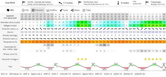
How do you interpret wind signals?
To interpret wind data on Windguru, you need to look at the wind speed and gusts. The speed is indicated in knots, and the color coding represents white, blue, and green for light winds, and red and pink for strong winds. The arrow indicates the wind direction, which is a crucial piece of information.
How do you read cloudiness on Windguru?
Cloudiness is measured in percentage and indicated as high/medium/low, providing a simple indication of whether it will be heavily or lightly cloudy.
What is GFS in Windguru?
GFS stands for the Global Forecast System, which is a weather prediction model created and used by the National Oceanic and Atmospheric Administration of the United States.
What is the isotherm on Windguru?
The isotherm is the altitude where the temperature reaches 0 degrees Celsius. It is only displayed if the model predicts temperatures below 5°C.
Can I fully rely on Windguru?
No, Windguru is still a forecasting tool. Its reliability depends greatly on the location. For example, in the case of Tarifa, the wind forecast is quite reliable, although it tends to predict less wind than what actually occurs. When it comes to wave forecasts, if the swell direction is west, the predicted size is usually accurate, but if there is some north in the swell, it tends to be significantly smaller than predicted. Ultimately, knowledge of the specific location will greatly help in interpreting Windguru's forecasts.
Products you may be interested in:

Sebas
Sebas is the passionate creator and founder of Mundo-Surf, a space dedicated to those who live and breathe surfing. With a deep connection to the ocean and an overflowing passion for every wave, Sebas has turned his love for surfing into a mission: to share, inspire, and educate the community.
In addition to being an avid surfer, Sebas is an expert in surfboard manufacturing, an art that combines technique and creativity. Through his blog, he not only offers guides, reviews, and advice but also shares his experience in surfboard creation, helping others understand the process behind each design and material. At Mundo-Surf, Sebas invites us all to discover surfing at its fullest, from the right equipment to the personalized creation of surfboards.